Advocates for Balanced Growth
This group sounds an urgent call to Knox County Residents,who acknowledge the need for growth, but also appreciatethe rural character of our region; agriculture and farms;the importance of soil, and low taxes.
The Advocates for Balanced Growth group was formed in fall 2023. The group and website has been retired, and folded into the KCPA umbrella. This provides the story of the initiative and an archive of documents.
For the short summary of the outcome, please read the statement we issued. Ultimately our advocacy efforts failed to substantially influence the Growth Plan or the General Plan. Knox county developers, long the dominant force in county politics, once again prevailed. The community forcefully pressed its argument, and when the final votes were cast, it was obvious which officials had listened to the county residents, and which officials remained beholden to the development community.
In October 2023, Knox County announced that it was reconvening the Growth Plan Coordinating Committee as the first step in legislating a new General Plan, the result of the Advance Knox initiative. The initial growth plan proposal was met with concern from a number of residents – not only KCPA advocates, but farmers, conservationists, urban and rural residents alike.
The community organized under the banner ‘Advocates for Balanced Growth‘ and setup the website knoxgrowth.org to inform the community and provide instructions on how to engage with leaders. Residents contributed suggestions through 4 meetings of the Coordinating Committee.
October 24, 2023 (video) an initial introductory meeting, where 6 residents addressed the committee with concerns
November 27, 2023 (video) the first of two required public hearings. 34 residents spoke. News coverage from WVLT, WBIR, WATE, Compass
December 19, 2023 (video) the second public hearing. 14 residents spoke. News coverage from Compass
January 10, 2024 (video). An updated plan was released just 48 hours before the meeting. Residents again spoke, but the committee passed the updated plan with 2 dissenting votes.
The plan then went to Knox County Commission, City of Knoxville and Town of Farragut for ratification. It passed all three bodies, although Farragut provided some drama when the Board of Mayor and Aldermen initially defeated the proposal, and then voted to reconsider it after county mayor Glenn Jacobs held a news conference and proceeded to apply pressure to the Aldermen.
While the Growth Plan was going through ratification, the county moved forward with it’s new Comprehensive Plan. The Planning Commission made a few small amendments, and then sent it to County Commission for enactment. KCPA and Advocates for Planned Growth published a proposal including amendments we supported and wrote an op-ed published in KnoxTN Today. Commissioner Kim Frazier introduced a number of amendments at the county commission workshop, but the following week Glenn Jacobs sent this letter to commission. The mayor’s opposition to proposed amendments effectively killed them. County Commission made some minor amendments to the plan and approved it on April 22, 2024.
KCPA and Advocates for Balanced Growth issued a joint statement, where we called out that this is a start on improving our land use policies, but tens of thousands of acres were opened up for new development.
Ultimately our advocacy efforts failed to substantially influence the Growth Plan or the General Plan. Knox county developers, long the dominant force in county politics, once again prevailed. The community forcefully pressed its argument, and when the final votes were cast, it was obvious which officials had listened to the county residents, and which officials remained beholden to the development community.
Below is an archive of our assessment of the situation, our concerns, and our proposals for the Growth Plan. This was written and published in November / December 2023. But first, a great video that some of our supports put together!
The Situation
Knox County is updating its Growth Plan and its Comprehensive Land Use Plan. These plans impact future land use and development. The old plans haven’t been working well for Knox County, resulting in a sprawl that eats up land.

The plan seeks to accommodate 79,000 new residents in Knox County over the next 20 years and will guide the location and development of new housing, shopping centers, restaurants, jobs, parks and roads.
It will also guide how (and whether) we preserve existing farms and valuable agricultural land. It documents where new development will overtake farms, open space and the rural character of our region.
Growth is inevitable, and we need to accommodate it, but we need BALANCED and smart planning that respects the character of our community.

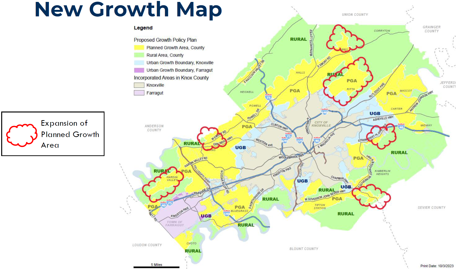
This map broadly depicts the areas where the Planned Growth Area will be expanded. Source: Oct 24, 2023 presentation to the Growth Policy Plan Coordinating Committee. An interactive comparison map is available here.
Land in the yellow “Planned Growth Area” is where growth is expected for the next 20 years. The Growth Plan places no restrictions on the General Plan’s Placetype (land use classification) in the Planned Growth Area. This area will be attractive for development opportunities, and should expect to see growth over the next 20 years.
The green “Rural Area” has restrictions on the Placetypes and density, which will better protect it for farmland, open space and conservation.
The current Planned Growth Area is being expanded in 6 areas:
- Washington Pike: 5,952 acres
- Hardin Valley: 2,957 acres
- Karns: 160 acres
- Chapman Highway: 589 acres
- Strawberry Plains: 384 acres
Updates to the map are in-process and will take effect after Knoxville City Council, Town of Farragut and Knox County Commission adopt them.
Our Concern
It matters what land is designated Planned Growth Area, and what is Rural Area on the Growth Plan Map.
We have concerns with the proposed Growth Plan Amendment map:
- Land in the Planned Growth Area has no land use or development restrictions at the Growth Plan Level; ultimately the land use is determined by a majority vote at County Commission when they vote on general plan amendments and rezonings.Bear with us – this first reason is technical, but VERY important.If land is in the Planned Growth Area, ALL TYPES OF DEVELOPMENT MAY BE CONSIDERED.
Summary: Land located in the Rural Area has considerable protections. But land in the Planned Growth Area – the land use and zoning are ultimately controlled by a simple majority vote of County Commission. So the Planned Growth or Rural designation really matters.The proposed Growth Plan policies permit any land use or development permitted by the county’s zoning ordinance in the Planned Growth Area (proposed policy 5.2). It allows consideration of all land use designations [we’re used to calling them Sector Plan designations; the new term will be Placetype].We agree with the policy – if it’s where we are growing, then the Growth Plan shouldn’t restrict it. BUT – this means development on land located within the Planned Growth Area is guided only by the Comprehensive Land Use Plan and the Zoning Ordinance – both of which are adopted, and modified, by County Commission.- The comprehensive plan’s draft Future Land Use Plan Map depicts which Placetypes should be located where, but it does not specify written criteria for where particular Placetypes are appropriate – criteria that would guide future professionals, planning commissioners, and legislative bodies.
- The draft Future Land Use Plan Map is just that – a draft – and there is no guarantee it will be adopted as-is. Areas that are currently depicted as “Rural Conservation” could be finalized as “Suburban Residential” by the time the land use map is considered by the Planning Commission adopted by County Commission.
- The Comprehensive Plan’s criteria for a plan update are the same criteria we have had in place for amending Sector Plans. Our experience is that these criteria are broad and wide, and many applicants are able to craft a justification under these criteria.
- Amending the Future Land Use Plan map requires going through Planning Commission, which makes a recommendation on the request, and then sends it to County Commission. We see this every month with Sector Plan requests at Planning Commission and County Commission. Ultimately, amending the Future Land Use Plan ultimately comes down to needing a majority vote of the County Commission.
In contrast, the Rural Area policies limit the Comprehensive Plan’s Placetypes to three (3) rural placteypes – Rural Living, Rural Conservation, Rural Crossroads Commercial. The policies also limit new residential development density to a maximum of 2 dwelling units / acre, and prohibit business parks and industrial zones (proposed policies 4.2 – 4.4). It would not be legal for a future County Commission to approve a Suburban Residential Placetype in the Rural Area of the Growth Plan
- Some of our best remaining farmland is located in the proposed Planned Growth Area. UT Extension estimates the direct agriculture output was $2,765.9 million in 2021 for Knox County (or, 2.77 billion). We need good soil and viable farms. We’ve learned a lot about growth, and Knox County, in the last 20 years. The Market Square Farmer’s Market is an economic engine for all of Knox County, bringing customers not only to local farmers but to restaurants and businesses downtown. Cruze Farm Dairy and Ice Cream is produced entirely from dairy cattle in Knox County. Our local agriculture is differentiator for us. We need farms with good soil to keep the agricultural industry intact.However, the new proposed Planned Growth Area starts out by keeping all prior land in the Planned Growth Area, and didn’t retract any of the prior boundaries. Some of the prior Planned Growth Area covers some of the county’s best remaining soil, such as along the Holston River north of Asheville Highway. If we want to continue to have agriculture in Knox County, we need to conserve prime farmland. Unfortunately, soil characteristics were not included as a Suitability Factor when modeling was conducted to determine the best places for development.

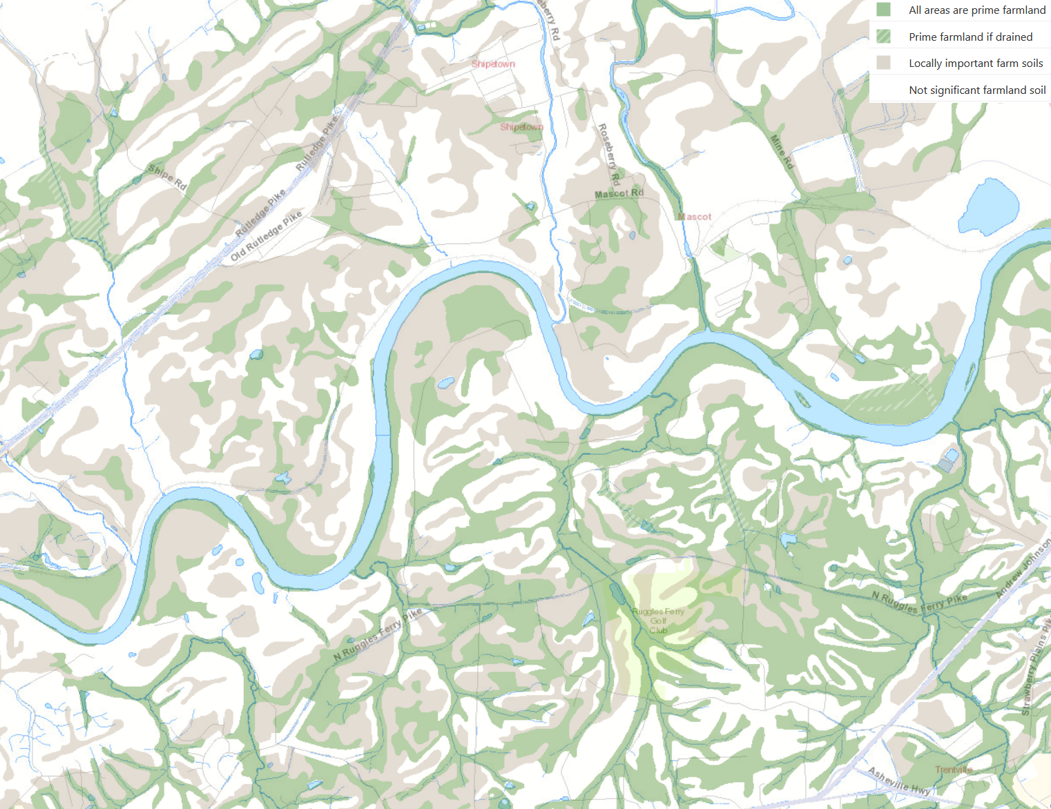
Soil map of the Holston River area. Green is prime farmland soil, brown is locally important farm soils. Note the rich soils on the south side of the Holston River, which local farmers tell us are some of the very best in the county. All of the land on this map was located in the 2001 Planned Growth Area, and was retained in the proposed Planned Growth Area. Source: KGIS Planning Cases
- Tennessee Century Farms are jewels of historic and landscape preservation. A number of Knox County’s Century Farms are located within the Planned Growth Area. Gregory Farms, Green Acres Farm, Murphy Spring Farm, and Yarnell Family Farms are located within the proposed Planned Growth Area. Tennessee Century Farms are jewels of historic and landscape preservation, and Knox County proposes that these should be located within the Planned Growth Area. Several other important farms, long farmed by the same family, are not officially recognized as Century Farms, but are located in the Planned Growth Area; in particular the Strong Stock Farm, Knox County’s largest farm, and the Blake Farm, with very rich soil on the Holston River.
- The two largest areas of Planned Growth expansion – Washington Pike and Hardin Valley – are in valleys with limited transportation connections. They also do not have substantial employment centers, meaning that most residents must commute out of those areas to employment, requiring substantial transportation investment in our roads, and substantial commuting costs to residents.
The Land Use and Transportation Plan identifies several capital projects for the Hardin Valley area, but doesn’t identify any for the Washington Pike / Ritta / Maloneyville areas. Funding for future projects is not available in the near-term, and unlikely for the mid-term. - Finally, the proposed Growth Plan Amendment opens up over 9,200 new acres of Planned Growth Area. This will create a new “land rush” in Knox County for developers who have been waiting for density restrictions to lift so that they can build more than 3 units per acre. With all of this new land available, our large homebuilders will continue with their current business model, instead of learning to do higher-density, mixed-use developments or more conversion / infill development.
What We Propose
We support planning that balances our growing population with the natural beauty and agrarian traditions of our county. New and infill growth should be well planned, attractive, and include developments with a variety of housing options, retail and restaurants, schools, parks, and other amenities for the growing population.
Our belief is this is best accomplished by focusing growth near existing infrastructure. If growth is needed away from existing infrastructure and services, then near-term funding must be identified for expanded infrastructure and services. We desire a combination of infill and more compact development along existing major corridors, and some modest expansion of the Planned Growth Area.
We do not support subdivisions sprawling out and onto our farmland. These cost us our rural landscape, they de-value or destroy agricultural assets and the livelihoods and traditions of farmers. Advance Knox’s fiscal analysis demonstrates that low density suburban residential is a net-loss for county taxpayers.
Farms, natural areas, and the urban proximity to these spaces are an important part of this region and why so many people have chosen to live, work, and raise our families in Knox County.
Again, we understand the need for growth, but we advocate building in ways that accommodate both the livelihoods of the farmers and communities around them (who have been here for decades and longer), AND the needs of new residents coming into our area.
We specifically ask that the Growth Plan Coordinating Committee consider and make amendments that:
- Retract (shrink) the Planned Growth Area for areas with Prime and Locally Important Farmland Soil and Environmental Habitat. Keep these spaces in the Rural Area.
- Place our Century Farms and large agricultural farms in the Rural Area. Century Farms have been farmed by the same family for more than 100 years.
- Promote a compact pattern of development, which will direct new growth and redevelopment to areas with infrastructure, thus reducing the cost of providing new services to far-flung areas of the country.
The map below is an exploration of what it could look like to retract the Planned Growth area.
The bright green areas are located within the proposed Planned Growth Area of the Growth Plan map, yet designated “Rural Conservation” Placetype in the draft Future Land Use Map.
Rural Conservation Placetypes are intended to conserve forested areas, ridges, wetlands, and other significant natural areas by clustering development and minimizing land disturbance. Generally, these areas conserve between 50-70 percent of a site as natural open space. (Full screen map, opens in new window)
Pulling these areas into the Rural Area would protect much of our Prime and Locally Important Farmland Soil.
Our Take on the Updated Growth Plan Proposal
The updates released on Monday Jan 8 have reduced a couple proposed expansions:
- The proposed expansion north of Gibbs is removed; this will remain Rural Area
- A portion of the Ritta / Maloneyville is removed – some areas that had significant Prime Farmland soil
- Two small areas in south Knox are removed
- There are minor updates to the text amendments, primarily clarifying the language, and setting an effective date of May 1, 2024 for the amendment.
- Notably – all areas currently designated Planned Growth Area will remain Planned Growth Area, including prime soil along the Holston River and several historic Century Farms
We view these as improvements, but we still have excellent farmland and natural areas / open space in our Planned Growth Areas. If it’s in the yellow area (Planned Growth) on the map, it is a target for development over the next 20 years. We think these are worth calling out for protection and moving them to the Rural Area. Finally, the hardest-impacted area – Ritta / Maloneyville, has 4,891 acres of new Planned Growth is proposed, but the county has not prioritized any new parks or transportation projects for funding. We don’t want to repeat Hardin Valley’s growth-without-infrastructure in that area.
Talking Points
If you are speaking, here are some talking points:
- If you don’t feel you have had time to fully review these changes, ask for the Growth Plan Committee to postpone taking action on Jan 10th.
- Today we intentionally designate areas for development – like highway corridors, town centers, commercial nodes. Why don’t we do the same and intentionally designate entire areas for agriculture, open space or natural areas, and adopt policies that encourage that land use? Areas for farming and open space should have underlying characters that make them ideal for that, particularly soil types, sensitive environmental habitats, scenic qualities. There are places inside the current Planned Growth that are some of the very best places remaining for agriculture, natural areas and open space in the county, and we need to intentionally designate them as Rural Areas. Once its developed, we lose that farmland, forever.
- Farmers need other farmers as neighbors, to build a community. Farmers help their neighbors out all the time, and farmers in proximity to farmers build a stronger farming community. And, the best neighbor for a farm is another farm or open space. Residential or commercial uses clash; kids cut fences and let livestock out, or neighbors think it’s OK to go 4-wheeling on that open land. Or next-door residents complain of smells or noise from tractors working long hours to get up a crop of hay. The best neighbor for a farm is another farm.
- Similarly, natural areas and open space near each other complement each other. A local example is House Mountain, which is complemented by the views of farms and rivers surrounding it. This contrasts with Sharps Ridge, an urban ridge with adjacent urban development that has a very different character. They both are great parks and serve the community, but they have very different characters because of adjacent land uses. If we don’t intentionally plan for land use around House Mountain, then the unsaid policy is that we are OK with it eventually transforming to an urban ridge environment.
- The planned expansion for Ritta and Washington Pike isn’t accompanied by transportation or services plans to serve that area. The whole county saw what happened when Hardin Valley’s growth exploded without a plan for accompanying services and infrastructure. We want to learn from mistakes, and northeast Knox community doesn’t want to have that mistake made again. We urge this expansion to be slowly phased over the next 20 years with perhaps updates to the Growth Plan Map in 5-8 years for the first or second phase. The expansion currently proposed, without any proposal and timeline to fund necessary projects, is a bad deal for current and future residents in those areas. Funding is already committed over the next 10-15 years to projects to address Hardin Valley and other areas. Any growth in northeast Knox would happen first, wait 10-15 years for the first transportation projects to hit the drawing board, and then take another 10+ years to implement.
This need for designating larger areas for ag, open space and natural area was driven home by an article in the Orlando Sentinel about the Orlando Airport. Years ago they built a 3rd runway and destroyed 320 acres of wetlands, and agreed to protect over 1,000 acres from future development. Today the airport authority is trying to remove a conservation arrangement for wetlands. From the Dec 10th 2023 Orlando Sentinel:
The airport authority also claims that Mud Lake and its wetlands have been spoiled by the region’s development. ‘Mud Lake will continue to become more isolated in the landscape reducing the wildlife connectivity and ecological function,’ Thibault said.
Florida developers commonly argue for destruction of an environmental property by claiming that encroaching construction or agriculture already has wrecked its natural qualities.
So what can we do? Considering agriculture, forest and open space and natural areas as areas instead of individual parcels is a good start.
Local Policy Ideas
The American Farmland Trust’s “Farms Under Threat 2040” (report link) has a section on WHAT LOCAL GOVERNMENTS CAN DO (page vii):
- Smart Growth: Create comprehensive plans, embrace zoning approaches that encourage compact growth, and proactively plan for agriculture.
- Farmland Protection: Identify agricultural resources and protect the agricultural land identified as a community priority.
- Smart Solar: Incorporate smart solar siting into local land-use decisions; develop solar land-use laws and permitting through inclusive processes; ensure solar strengthens farm viability; and ensure best practices for soil health are followed when siting solar on farmland.
- Farmland Access: Make municipal and county-owned lands available for agriculture and help match farm seekers with agricultural landowners.
Questions and Comments From Community Meetings
- What happened to the results of the listening tour? Were they included in the plan?
- How is the soil data being used?
- There was a suitability analysis that included some transportation patterns and access to schools, but it did not include the agricultural value of land or incorporate soil data.
- To be effective we need to include a map of our suggestions for growth.
- If we are expecting 75,000 poeple over 20 years, they have to go somewhere. If we are asking them to reduce the map then where are they going to go? We should offer suggestions.
- What is the current capacity of the current plan in absence of the additions in the new plan?
- How does the sewer line impact growth?
- We need to remind people about the existence of and the number of Century Farms in the region.
- It’s not always about where we develop, but how we develop. A good example of new development that is walkable, high density is Northshore Town Center.
- How will lifting density restrictions in the current plan allow for more efficient development that could play into reducing the scope of the new plan?
- Development in some of these areas will encourage farms to sell. It changes the character of the area and, per the farmers, the new residents don’t respect the farms. There are stories of people moving in to areas near farms and planting things like Russian Sage along the property which is toxic to cattle.
- There are other issues associated with development that compromise pollinators and species diversity.
- We have had experiences with people trespassing, thinking it’s ok to use open spaces for various activities or fish in our farm ponds.
- If people don’t see hay or horses or anything, they assume there’s nothing going on with the land.
- Development slowly erodes the farms.
- Increased traffic and streetlights changes the character and livelihoods.
- What amendments can be put in place to protect farms and soil?
- Other efforts were successful because they pointed out the faults in traffic patterns. They had the data and when no one listened they sued. A perfect example is the failed effort to build ‘Innsbruck Farms’ on Ruggles Ferry.
Our Supporters
Farms and Farmers
Blake Farm, Ruggles Ferry
Bullrun Farm, Heiskell
Chandler Tree Farm, Cedar Grove
Copeland Farms, Corryton
DeBevoise Farm, Ruggles Ferry
Don Gordon, South Knox County
Green Acres Farm, Mascot
Hartsong Farm, Ritta
G T Farms, Carter
Joker Farm / Holston River Bison, Ruggles Ferry
Maple Grove Farm, Ritta
McFalls Family Farms,
Murphy Springs Farm, Ritta
Rocking Chair Farm, Corryton
Strong Stock Farm, Rutledge Pike
Stoutt Farm, Ruggles Ferry
Tindell Farms, Corryton
Thompson Tender Beef, Corryton
Vannland Farm, Ruggles Ferry
Zavels Family Farms, Corryton
Other Organizations
Knox-Union Cattleman’s Association
Tennessee Foundation for Conservation and Stewardship
Neighborhoods and Community Groups
French Broad Preservation Association
Gibbs Planning Advocates
Hardin Valley Planning Advocates
Knox County Planning Alliance (KCPA)
Northshore Corridor Association
Ritta Planning Advocates
Ruggles Ferry Community Association
